13
views
0
recommends
+1 Recommend
0 collections
    0
    shares
      • Record: found
      • Abstract: found
      • Article: found
      Is Open Access

      Vision-Based Target Finding and Inspection of a Ground Target Using a Multirotor UAV System

      research-article

      Read this article at

      Bookmark
          There is no author summary for this article yet. Authors can add summaries to their articles on ScienceOpen to make them more accessible to a non-specialist audience.

          Abstract

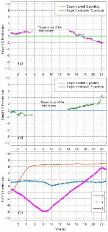
          In this paper, a system that uses an algorithm for target detection and navigation and a multirotor Unmanned Aerial Vehicle (UAV) for finding a ground target and inspecting it closely is presented. The system can also be used for accurate and safe delivery of payloads or spot spraying applications in site-specific crop management. A downward-looking camera attached to a multirotor is used to find the target on the ground. The UAV descends to the target and hovers above the target for a few seconds to inspect the target. A high-level decision algorithm based on an OODA (observe, orient, decide, and act) loop was developed as a solution to address the problem. Navigation of the UAV was achieved by continuously sending local position messages to the autopilot via Mavros. The proposed system performed hovering above the target in three different stages: locate, descend, and hover. The system was tested in multiple trials, in simulations and outdoor tests, from heights of 10 m to 40 m. Results show that the system is highly reliable and robust to sensor errors, drift, and external disturbance.

          Related collections

          Most cited references31

          • Record: found
          • Abstract: found
          • Article: found
          Is Open Access

          Weed Mapping in Early-Season Maize Fields Using Object-Based Analysis of Unmanned Aerial Vehicle (UAV) Images

          The use of remote imagery captured by unmanned aerial vehicles (UAV) has tremendous potential for designing detailed site-specific weed control treatments in early post-emergence, which have not possible previously with conventional airborne or satellite images. A robust and entirely automatic object-based image analysis (OBIA) procedure was developed on a series of UAV images using a six-band multispectral camera (visible and near-infrared range) with the ultimate objective of generating a weed map in an experimental maize field in Spain. The OBIA procedure combines several contextual, hierarchical and object-based features and consists of three consecutive phases: 1) classification of crop rows by application of a dynamic and auto-adaptive classification approach, 2) discrimination of crops and weeds on the basis of their relative positions with reference to the crop rows, and 3) generation of a weed infestation map in a grid structure. The estimation of weed coverage from the image analysis yielded satisfactory results. The relationship of estimated versus observed weed densities had a coefficient of determination of r2=0.89 and a root mean square error of 0.02. A map of three categories of weed coverage was produced with 86% of overall accuracy. In the experimental field, the area free of weeds was 23%, and the area with low weed coverage (<5% weeds) was 47%, which indicated a high potential for reducing herbicide application or other weed operations. The OBIA procedure computes multiple data and statistics derived from the classification outputs, which permits calculation of herbicide requirements and estimation of the overall cost of weed management operations in advance.
            Bookmark
            • Record: found
            • Abstract: found
            • Article: found
            Is Open Access

            Towards the Development of a Low Cost Airborne Sensing System to Monitor Dust Particles after Blasting at Open-Pit Mine Sites

            Blasting is an integral part of large-scale open cut mining that often occurs in close proximity to population centers and often results in the emission of particulate material and gases potentially hazardous to health. Current air quality monitoring methods rely on limited numbers of fixed sampling locations to validate a complex fluid environment and collect sufficient data to confirm model effectiveness. This paper describes the development of a methodology to address the need of a more precise approach that is capable of characterizing blasting plumes in near-real time. The integration of the system required the modification and integration of an opto-electrical dust sensor, SHARP GP2Y10, into a small fixed-wing and multi-rotor copter, resulting in the collection of data streamed during flight. The paper also describes the calibration of the optical sensor with an industry grade dust-monitoring device, Dusttrak 8520, demonstrating a high correlation between them, with correlation coefficients (R2) greater than 0.9. The laboratory and field tests demonstrate the feasibility of coupling the sensor with the UAVs. However, further work must be done in the areas of sensor selection and calibration as well as flight planning.
              Bookmark
              • Record: found
              • Abstract: found
              • Article: found
              Is Open Access

              Vision and Control for UAVs: A Survey of General Methods and of Inexpensive Platforms for Infrastructure Inspection

              Unmanned aerial vehicles (UAVs) have gained significant attention in recent years. Low-cost platforms using inexpensive sensor payloads have been shown to provide satisfactory flight and navigation capabilities. In this report, we survey vision and control methods that can be applied to low-cost UAVs, and we list some popular inexpensive platforms and application fields where they are useful. We also highlight the sensor suites used where this information is available. We overview, among others, feature detection and tracking, optical flow and visual servoing, low-level stabilization and high-level planning methods. We then list popular low-cost UAVs, selecting mainly quadrotors. We discuss applications, restricting our focus to the field of infrastructure inspection. Finally, as an example, we formulate two use-cases for railway inspection, a less explored application field, and illustrate the usage of the vision and control techniques reviewed by selecting appropriate ones to tackle these use-cases. To select vision methods, we run a thorough set of experimental evaluations.
                Bookmark

                Author and article information

                Journal
                Sensors (Basel)
                Sensors (Basel)
                sensors
                Sensors (Basel, Switzerland)
                MDPI
                1424-8220
                17 December 2017
                December 2017
                : 17
                : 12
                : 2929
                Affiliations
                Robotics and autonomous systems, Queensland University of Technology (QUT), Brisbane City QLD 4000, Australia; Jonathan.roberts@ 123456qut.edu.au (J.M.R.); felipe.gonzalez@ 123456qut.edu.au (F.G.)
                Author notes
                [* ]Correspondence: ajmal.hinas@ 123456hdr.qut.edu.au ; Tel.: +61-0469752697
                Article
                sensors-17-02929
                10.3390/s17122929
                5751607
                29258211
                31110d30-25df-4a87-acf5-72ef52704650
                © 2017 by the authors.

                Licensee MDPI, Basel, Switzerland. This article is an open access article distributed under the terms and conditions of the Creative Commons Attribution (CC BY) license ( http://creativecommons.org/licenses/by/4.0/).

                History
                : 04 November 2017
                : 15 December 2017
                Categories
                Article

                Biomedical engineering
                unmanned aerial vehicles,vision-based navigation,vision and action,ooda,remote sensing,inspection,target detection

                Comments

                Comment on this article