1
views
0
recommends
+1 Recommend
0 collections
    0
    shares
      • Record: found
      • Abstract: found
      • Article: found
      Is Open Access

      Water Identification from High-Resolution Remote Sensing Images Based on Multidimensional Densely Connected Convolutional Neural Networks

      , , ,
      Remote Sensing
      MDPI AG

      Read this article at

      Bookmark
          There is no author summary for this article yet. Authors can add summaries to their articles on ScienceOpen to make them more accessible to a non-specialist audience.

          Abstract

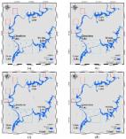
          The accurate acquisition of water information from remote sensing images has become important in water resources monitoring and protections, and flooding disaster assessment. However, there are significant limitations in the traditionally used index for water body identification. In this study, we have proposed a deep convolutional neural network (CNN), based on the multidimensional densely connected convolutional neural network (DenseNet), for identifying water in the Poyang Lake area. The results from DenseNet were compared with the classical convolutional neural networks (CNNs): ResNet, VGG, SegNet and DeepLab v3+, and also compared with the Normalized Difference Water Index (NDWI). Results have indicated that CNNs are superior to the water index method. Among the five CNNs, the proposed DenseNet requires the shortest training time for model convergence, besides DeepLab v3+. The identification accuracies are evaluated through several error metrics. It is shown that the DenseNet performs much better than the other CNNs and the NDWI method considering the precision of identification results; among those, the NDWI performance is by far the poorest. It is suggested that the DenseNet is much better in distinguishing water from clouds and mountain shadows than other CNNs.

          Related collections

          Most cited references9

          • Record: found
          • Abstract: not found
          • Article: not found

          Evaluation: From precision, recall, and F-measure to ROC, informedness, markedness & correlation

            Bookmark
            • Record: found
            • Abstract: not found
            • Article: not found

            Water body detection and delineation with landsat tm data

              Bookmark
              • Record: found
              • Abstract: found
              • Article: found
              Is Open Access

              Identification of Water Bodies in a Landsat 8 OLI Image Using a J48 Decision Tree

              Water bodies are essential to humans and other forms of life. Identification of water bodies can be useful in various ways, including estimation of water availability, demarcation of flooded regions, change detection, and so on. In past decades, Landsat satellite sensors have been used for land use classification and water body identification. Due to the introduction of a New Operational Land Imager (OLI) sensor on Landsat 8 with a high spectral resolution and improved signal-to-noise ratio, the quality of imagery sensed by Landsat 8 has improved, enabling better characterization of land cover and increased data size. Therefore, it is necessary to explore the most appropriate and practical water identification methods that take advantage of the improved image quality and use the fewest inputs based on the original OLI bands. The objective of the study is to explore the potential of a J48 decision tree (JDT) in identifying water bodies using reflectance bands from Landsat 8 OLI imagery. J48 is an open-source decision tree. The test site for the study is in the Northern Han River Basin, which is located in Gangwon province, Korea. Training data with individual bands were used to develop the JDT model and later applied to the whole study area. The performance of the model was statistically analysed using the kappa statistic and area under the curve (AUC). The results were compared with five other known water identification methods using a confusion matrix and related statistics. Almost all the methods showed high accuracy, and the JDT was successfully applied to the OLI image using only four bands, where the new additional deep blue band of OLI was found to have the third highest information gain. Thus, the JDT can be a good method for water body identification based on images with improved resolution and increased size.
                Bookmark

                Author and article information

                Contributors
                Journal
                Remote Sensing
                Remote Sensing
                MDPI AG
                2072-4292
                March 2020
                March 02 2020
                : 12
                : 5
                : 795
                Article
                10.3390/rs12050795
                58790b98-f515-4115-a257-244c6909d514
                © 2020

                https://creativecommons.org/licenses/by/4.0/

                History

                Comments

                Comment on this article