21
views
0
recommends
+1 Recommend
0 collections
    0
    shares
      • Record: found
      • Abstract: found
      • Article: found
      Is Open Access

      Stand-Alone GNSS Sensors as Velocity Seismometers: Real-Time Monitoring and Earthquake Detection

      research-article

      Read this article at

      Bookmark
          There is no author summary for this article yet. Authors can add summaries to their articles on ScienceOpen to make them more accessible to a non-specialist audience.

          Abstract

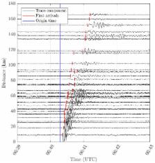
          By means of the time derivatives of Global Navigation Satellite System (GNSS) carrier-phase measurements, the instantaneous velocity of a stand-alone, single GNSS receiver can be estimated with a high precision of a few mm/s; it is feasible to even obtain the level of tenths of mm/s. Therefore, only data from the satellite navigation message are needed, thus discarding any data from a reference network. Combining this method with an efficient movement-detection algorithm opens some interesting applications for geohazard monitoring; an example is the detection of strong earthquakes. This capability is demonstrated for a case study of the 6.5 Mw earthquake of October 30, 2016, near the city of Norcia in Italy; in that region, there are densely deployed GNSS stations. It is shown that GNSS sensors can detect seismic compressional (P) waves, which are the first to arrive at a measurement station. These findings are substantiated by a comparison with data of strong-motion (SM) seismometers. Furthermore, it is shown that the GNSS-only hypocenter localization comes close (less than a kilometer) to the solutions provided by official seismic services. Finally, we conclude that this method can provide important contributions to a real-time geohazard early-warning system.

          Related collections

          Most cited references32

          • Record: found
          • Abstract: not found
          • Article: not found

          The 2016 Central Italy Seismic Sequence: A First Look at the Mainshocks, Aftershocks, and Source Models

            Bookmark
            • Record: found
            • Abstract: found
            • Article: not found

            Using 1-Hz GPS data to measure deformations caused by the Denali fault earthquake.

            The 3 November 2002 moment magnitude 7.9 Denali fault earthquake generated large, permanent surface displacements in Alaska and large-amplitude surface waves throughout western North America. We find good agreement between strong ground-motion records integrated to displacement and 1-hertz Global Positioning System (GPS) position estimates collected approximately 140 kilometers from the earthquake epicenter. One-hertz GPS receivers also detected seismic surface waves 750 to 3800 kilometers from the epicenter, whereas these waves saturated many of the seismic instruments in the same region. High-frequency GPS increases the dynamic range and frequency bandwidth of ground-motion observations, providing another tool for studying earthquake processes.
              Bookmark
              • Record: found
              • Abstract: not found
              • Article: not found

              Empirical Equations for the Prediction of PGA, PGV, and Spectral Accelerations in Europe, the Mediterranean Region, and the Middle East

                Bookmark

                Author and article information

                Journal
                Sensors (Basel)
                Sensors (Basel)
                sensors
                Sensors (Basel, Switzerland)
                MDPI
                1424-8220
                31 October 2018
                November 2018
                : 18
                : 11
                : 3712
                Affiliations
                ETH Zurich, Institute of Geodesy and Photogrammetry, 8093 Zurich, Switzerland; alain.geiger@ 123456geod.baug.ethz.ch
                Author notes
                Author information
                https://orcid.org/0000-0001-9617-2920
                Article
                sensors-18-03712
                10.3390/s18113712
                6263520
                30384502
                76d21b21-ece7-4035-aa40-18e72a4702aa
                © 2018 by the authors.

                Licensee MDPI, Basel, Switzerland. This article is an open access article distributed under the terms and conditions of the Creative Commons Attribution (CC BY) license ( http://creativecommons.org/licenses/by/4.0/).

                History
                : 10 October 2018
                : 30 October 2018
                Categories
                Article

                Biomedical engineering
                high-precision gnss,instantaneous gnss velocity,significance testing,gnss seismology,geohazard monitoring,seismic monitoring,earthquake early warning

                Comments

                Comment on this article