- Record: found
- Abstract: found
- Article: found
Why taxi tracking trumps tracking passengers with apps in planning for the electrification of Africa’s paratransit

Read this article at
Summary
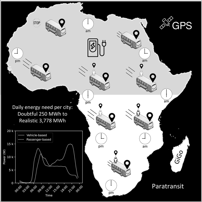
Decarbonisation of Africa’s informal paratransit through electrification requires adequate data captured correctly. Field workers getting on-board as passengers with tracked phones are extensively used to measure flow rates and volumes of passengers and vehicles on sections of roads in transport planning applications. Although this method is acceptable for transport planning, it is inadequate for planning for electrification. Combustion engine vehicles have long ranges and refill fast. Drivers and fuel outlets have existed in a symbiotic relationship without the bondage of needing detailed mobility information and planning. With electrification, battery-powered vehicles have become inextricably coupled to roadside infrastructure through their mobility patterns. We compare the current state of public transport data with vehicle tracking data for forecasting the electrification of Africa’s paratransit. Discrepancies between them highlight the problem with using incomplete and/or unreliable data to estimate a city’s peak load, pointing to a need for vehicle-based data acquisition.
Graphical abstract
Highlights
-
•
Energy forecasting for paratransit electrification planning of seven African cities
-
•
Energy needs per city vary wildly, with the reliability of the city’s GTFS data
-
•
Discrepancies highlight the problem with using unreliable transport data
-
•
Public transport data (GTFS) is not suitable for electrification planning
-
•
Vehicle-based GPS data should be used for electrification planning of paratransit
Abstract
Energy resources; Energy policy; Energy Modeling; Energy transportation
Related collections
Most cited references21
- Record: found
- Abstract: not found
- Article: not found
Informal transport: A global perspective
- Record: found
- Abstract: not found
- Article: not found
Motorcycle-taxis in sub-Saharan Africa: Current knowledge, implications for the debate on “informal” transport and research needs
- Record: found
- Abstract: not found
- Article: not found