0
views
0
recommends
+1 Recommend
0 collections
    0
    shares
      • Record: found
      • Abstract: found
      • Article: found
      Is Open Access

      Pre-existing structural control on the recent Holuhraun eruptions along the Bárðarbunga spreading center, Iceland

      research-article

      Read this article at
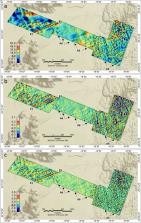
      Bookmark
          There is no author summary for this article yet. Authors can add summaries to their articles on ScienceOpen to make them more accessible to a non-specialist audience.

          Abstract

          The active rift zones in Iceland provide unique insight into the geodynamic processes of divergent plate boundaries. The geodynamics of Iceland are studied intensively, particularly, by geophysical methods sensitive to active and/or visible structures such as earthquake seismic and Synthetic Aperture Radar observations or aerial photographs. However, older and less active structures, that may exert a strong control on the presently active geodynamics, are often buried beneath recent volcanic or sedimentary deposits and are—due to their passive mode—overseen by the typical geophysical investigations. Aeromagnetic surveys provide spatial information about subsurface magnetization contrasts relating to both active and inactive structures. However, the aeromagnetic data in Iceland were collected in the 1970-80s and are relevant only to large-scale regional rift studies. With the availability of reliable drones and light-weight atomic scalar sensors, high-quality drone magnetic surveys can provide an unprecedented spatial resolution of both active and passive structures of rift systems as compared to conventional airborne surveys. Here, we present the results of a drone-towed magnetic scalar field and scalar gradiometry study of the north-northeast trending Bárðarbunga spreading center to the north of the Vatnajökull ice cap, Iceland. Our results provide new information about the structural complexity of rift zones with evidence of densely-spaced, conjugate and oblique faults throughout the area. Evidence is shown of a hitherto unknown and prominent east-northeast trending fault structure that coincides with the northern tip of the main eruption edifice of the 1797 and 2014-15 Holuhraun volcanic events. We suggest that this pre-existing structure controlled the locus of vertical magma migration during the two Holuhraun events.

          Related collections

          Most cited references50

          • Record: found
          • Abstract: not found
          • Article: not found

          Geologically current plate motions

            Bookmark
            • Record: found
            • Abstract: found
            • Article: not found

            Segmented lateral dyke growth in a rifting event at Bárðarbunga volcanic system, Iceland.

            Crust at many divergent plate boundaries forms primarily by the injection of vertical sheet-like dykes, some tens of kilometres long. Previous models of rifting events indicate either lateral dyke growth away from a feeding source, with propagation rates decreasing as the dyke lengthens, or magma flowing vertically into dykes from an underlying source, with the role of topography on the evolution of lateral dykes not clear. Here we show how a recent segmented dyke intrusion in the Bárðarbunga volcanic system grew laterally for more than 45 kilometres at a variable rate, with topography influencing the direction of propagation. Barriers at the ends of each segment were overcome by the build-up of pressure in the dyke end; then a new segment formed and dyke lengthening temporarily peaked. The dyke evolution, which occurred primarily over 14 days, was revealed by propagating seismicity, ground deformation mapped by Global Positioning System (GPS), interferometric analysis of satellite radar images (InSAR), and graben formation. The strike of the dyke segments varies from an initially radial direction away from the Bárðarbunga caldera, towards alignment with that expected from regional stress at the distal end. A model minimizing the combined strain and gravitational potential energy explains the propagation path. Dyke opening and seismicity focused at the most distal segment at any given time, and were simultaneous with magma source deflation and slow collapse at the Bárðarbunga caldera, accompanied by a series of magnitude M > 5 earthquakes. Dyke growth was slowed down by an effusive fissure eruption near the end of the dyke. Lateral dyke growth with segment barrier breaking by pressure build-up in the dyke distal end explains how focused upwelling of magma under central volcanoes is effectively redistributed over long distances to create new upper crust at divergent plate boundaries.
              Bookmark
              • Record: found
              • Abstract: not found
              • Article: not found

              Earthquakes and present-day tectonism in Iceland

                Bookmark

                Author and article information

                Contributors
                ards@space.dtu.dk
                Journal
                Sci Rep
                Sci Rep
                Scientific Reports
                Nature Publishing Group UK (London )
                2045-2322
                10 February 2024
                10 February 2024
                2024
                : 14
                : 3399
                Affiliations
                [1 ]GRID grid.5170.3, ISNI 0000 0001 2181 8870, Crustal Magnetometry Technology & Research Group (CMAGTRES), Division of Geomagnetism & Geospace, , DTU Space, ; Centrifugevej 356, 2850 Kgs., Lyngby, Denmark
                [2 ]UMag Solutions Aps, Nørgaardsvej 26, 2800 Lyngby, Denmark
                [3 ]Department of Earth Science and Engineering, Imperial College London, South Kensington Campus, ( https://ror.org/041kmwe10) London, SW7 2AZ UK
                [4 ]Department of Earth Sciences, University College London, ( https://ror.org/02jx3x895) Gower Street, London, WC1E 6BT UK
                [5 ]Faroes Geological Survey, 34 Jóannesar Paturssonar gøta, Tórshavn, 100 Faroe Islands
                Article
                53790
                10.1038/s41598-024-53790-x
                10858284
                38336866
                a6cb08e1-3427-4123-8554-4dc951e59fa5
                © The Author(s) 2024

                Open Access This article is licensed under a Creative Commons Attribution 4.0 International License, which permits use, sharing, adaptation, distribution and reproduction in any medium or format, as long as you give appropriate credit to the original author(s) and the source, provide a link to the Creative Commons licence, and indicate if changes were made. The images or other third party material in this article are included in the article’s Creative Commons licence, unless indicated otherwise in a credit line to the material. If material is not included in the article’s Creative Commons licence and your intended use is not permitted by statutory regulation or exceeds the permitted use, you will need to obtain permission directly from the copyright holder. To view a copy of this licence, visit http://creativecommons.org/licenses/by/4.0/.

                History
                : 25 August 2023
                : 5 February 2024
                Categories
                Article
                Custom metadata
                © Springer Nature Limited 2024

                Uncategorized
                geodynamics,geology,geomagnetism,geophysics,palaeomagnetism,tectonics,volcanology
                Uncategorized
                geodynamics, geology, geomagnetism, geophysics, palaeomagnetism, tectonics, volcanology

                Comments

                Comment on this article