22
views
0
recommends
+1 Recommend
0 collections
    0
    shares
      • Record: found
      • Abstract: found
      • Article: found
      Is Open Access

      Unmanned Aerial Vehicle Systems for Remote Estimation of Flooded Areas Based on Complex Image Processing

      research-article

      Read this article at

      Bookmark
          There is no author summary for this article yet. Authors can add summaries to their articles on ScienceOpen to make them more accessible to a non-specialist audience.

          Abstract

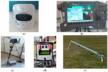
          Floods are natural disasters which cause the most economic damage at the global level. Therefore, flood monitoring and damage estimation are very important for the population, authorities and insurance companies. The paper proposes an original solution, based on a hybrid network and complex image processing, to this problem. As first novelty, a multilevel system, with two components, terrestrial and aerial, was proposed and designed by the authors as support for image acquisition from a delimited region. The terrestrial component contains a Ground Control Station, as a coordinator at distance, which communicates via the internet with more Ground Data Terminals, as a fixed nodes network for data acquisition and communication. The aerial component contains mobile nodes—fixed wing type UAVs. In order to evaluate flood damage, two tasks must be accomplished by the network: area coverage and image processing. The second novelty of the paper consists of texture analysis in a deep neural network, taking into account new criteria for feature selection and patch classification. Color and spatial information extracted from chromatic co-occurrence matrix and mass fractal dimension were used as well. Finally, the experimental results in a real mission demonstrate the validity of the proposed methodologies and the performances of the algorithms.

          Related collections

          Most cited references39

          • Record: found
          • Abstract: not found
          • Article: not found

          Mobile 3D mapping for surveying earthwork projects using an Unmanned Aerial Vehicle (UAV) system

            Bookmark
            • Record: found
            • Abstract: not found
            • Article: not found
            Is Open Access

            Urban Flood Mapping Based on Unmanned Aerial Vehicle Remote Sensing and Random Forest Classifier—A Case of Yuyao, China

              Bookmark
              • Record: found
              • Abstract: not found
              • Article: not found

              Investigation of uav systems and flight modes for photogrammetric applications

                Bookmark

                Author and article information

                Contributors
                Role: Academic Editor
                Role: Academic Editor
                Journal
                Sensors (Basel)
                Sensors (Basel)
                sensors
                Sensors (Basel, Switzerland)
                MDPI
                1424-8220
                23 February 2017
                March 2017
                : 17
                : 3
                : 446
                Affiliations
                Department of Control Engineering and Industrial Informatics, University Politehnica of Bucharest, Bucharest 060042, Romania; loretta.ichim@ 123456upb.ro (L.I.); florin.stoican@ 123456upb.ro (F.S.)
                Author notes
                [* ]Correspondence: dan.popescu@ 123456upb.ro or dan_popescu_2002@ 123456yahoo.com ; Tel.: +40-76-621-8363
                Article
                sensors-17-00446
                10.3390/s17030446
                5375732
                28241479
                37d8c9da-50d1-4d9b-ac18-708ffc1cfc1a
                © 2017 by the authors.

                Licensee MDPI, Basel, Switzerland. This article is an open access article distributed under the terms and conditions of the Creative Commons Attribution (CC BY) license ( http://creativecommons.org/licenses/by/4.0/).

                History
                : 28 December 2016
                : 20 February 2017
                Categories
                Article

                Biomedical engineering
                unmanned aerial vehicle,path planning,flood detection,feature selection,image processing,image segmentation,texture analysis

                Comments

                Comment on this article