12
views
0
recommends
+1 Recommend
0 collections
    0
    shares
      • Record: found
      • Abstract: found
      • Article: found
      Is Open Access

      Local climate zone-based urban land cover classification from multi-seasonal Sentinel-2 images with a recurrent residual network

      research-article

      Read this article at

      Bookmark
          There is no author summary for this article yet. Authors can add summaries to their articles on ScienceOpen to make them more accessible to a non-specialist audience.

          Abstract

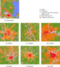
          The local climate zone (LCZ) scheme was originally proposed to provide an interdisciplinary taxonomy for urban heat island (UHI) studies. In recent years, the scheme has also become a starting point for the development of higher-level products, as the LCZ classes can help provide a generalized understanding of urban structures and land uses. LCZ mapping can therefore theoretically aid in fostering a better understanding of spatio-temporal dynamics of cities on a global scale. However, reliable LCZ maps are not yet available globally. As a first step toward automatic LCZ mapping, this work focuses on LCZ-derived land cover classification, using multi-seasonal Sentinel-2 images. We propose a recurrent residual network (Re-ResNet) architecture that is capable of learning a joint spectral-spatial-temporal feature representation within a unitized framework. To this end, a residual convolutional neural network (ResNet) and a recurrent neural network (RNN) are combined into one end-to-end architecture. The ResNet is able to learn rich spectral-spatial feature representations from single-seasonal imagery, while the RNN can effectively analyze temporal dependencies of multi-seasonal imagery. Cross validations were carried out on a diverse dataset covering seven distinct European cities, and a quantitative analysis of the experimental results revealed that the combined use of the multi-temporal information and Re-ResNet results in an improvement of approximately 7 percent points in overall accuracy. The proposed framework has the potential to produce consistent-quality urban land cover and LCZ maps on a large scale, to support scientific progress in fields such as urban geography and urban climatology.

          Related collections

          Most cited references30

          • Record: found
          • Abstract: found
          • Article: not found

          LSTM: A Search Space Odyssey

          Several variants of the long short-term memory (LSTM) architecture for recurrent neural networks have been proposed since its inception in 1995. In recent years, these networks have become the state-of-the-art models for a variety of machine learning problems. This has led to a renewed interest in understanding the role and utility of various computational components of typical LSTM variants. In this paper, we present the first large-scale analysis of eight LSTM variants on three representative tasks: speech recognition, handwriting recognition, and polyphonic music modeling. The hyperparameters of all LSTM variants for each task were optimized separately using random search, and their importance was assessed using the powerful functional ANalysis Of VAriance framework. In total, we summarize the results of 5400 experimental runs ( ≈ 15 years of CPU time), which makes our study the largest of its kind on LSTM networks. Our results show that none of the variants can improve upon the standard LSTM architecture significantly, and demonstrate the forget gate and the output activation function to be its most critical components. We further observe that the studied hyperparameters are virtually independent and derive guidelines for their efficient adjustment.
            Bookmark
            • Record: found
            • Abstract: not found
            • Article: not found

            Local Climate Zones for Urban Temperature Studies

              Bookmark
              • Record: found
              • Abstract: not found
              • Article: not found

              Deep Learning in Remote Sensing: A Comprehensive Review and List of Resources

                Bookmark

                Author and article information

                Contributors
                Journal
                ISPRS J Photogramm Remote Sens
                ISPRS J Photogramm Remote Sens
                Isprs Journal of Photogrammetry and Remote Sensing
                Elsevier
                0924-2716
                1872-8235
                1 August 2019
                August 2019
                : 154
                : 151-162
                Affiliations
                [a ]Signal Processing in Earth Observation (SiPEO), Technical University of Munich (TUM), Arcisstr. 21, 80333 Munich, Germany
                [b ]Remote Sensing Technology Institute (IMF), German Aerospace Center (DLR), Oberpfaffenhofen, 82234 Wessling, Germany
                Author notes
                [* ]Corresponding author at: Remote Sensing Technology Institute (IMF), German Aerospace Center (DLR), Oberpfaffenhofen, 82234 Wessling, Germany. xiaoxiang.zhu@ 123456dlr.de
                Article
                S0924-2716(19)30126-1
                10.1016/j.isprsjprs.2019.05.004
                6686635
                31417230
                a3a8f647-8c63-4907-8c0c-51f92062a6a2
                © 2019 The Author(s)

                This is an open access article under the CC BY license (http://creativecommons.org/licenses/by/4.0/).

                History
                : 2 January 2019
                : 9 May 2019
                : 21 May 2019
                Categories
                Article

                land cover,local climate zones (lczs),sentinel-2,multi-seasonal,residual convolutional neural network (resnet),long short-term memory (lstm),recurrent neural network (rnn)

                Comments

                Comment on this article